
DISCLAIMER
The draft recommendations contained herein were preliminary drafts submitted for discussion purposes only and do not constitute final determinations. They have been subject to modification, substitution, or rejection and may not reflect the adopted positions of IFATCA. For the most current version of all official policies, including the identification of any documents that have been superseded or amended, please refer to the IFATCA Technical and Professional Manual (TPM).
62ND ANNUAL CONFERENCE, Montego Bay, Jamaica, 8-12 May 2023WP No. 95Navigation – Magnetic vs TruePresented by TOC |
Summary
Since the early days of aviation aircraft have navigated using Magnetic North as reference. However, in the polar region it is not a reliable method due to extreme magnetic variations, and navigation there is based on True North. The movement of the Magnetic North Pole creates costs – runways have to be renumbered, navaids and aircraft databases kept up to date. This paper examines possible advantages of global introduction of True North based navigation.
Introduction
1.1. Canada has established a working group to develop the CONOPS and a plan for transition from Magnetic to True North also outside the Northern Domestic Airspace where true reference is already being used. The target timeline for the change being 2030.
1.2. The Altitude Heading Reference Transition Action Group (AHRTAG) of the International Association of Institutes of Navigation (IAIN) has held monthly meetings to study the change to True North internationally.
1.3. Magnetic poles move. For example, according to the European Space Agency (ESA) the Magnetic North Pole is moving towards Siberia approximately 50-60 km per year. Until 1990 the speed stayed between 0-15 km per year. Forecasts for conversion databases are inaccurate.
1.4. Inertial technology uses true north. After completing track calculations with reference to true north, IRU/FMS (Inertial Reference Unit/Flight Management System) use their internal variation database to provide a magnetic track. These databases can be out of date/contain slightly different data. Therefore the tracks displayed on FMS can differ from the published charts.
1.5. Regular update of databases, charts and runway markings is expensive. Also VORs must be rotated and modified instrument procedures flight checked.
1.6. Weather services use true reference for wind information (METAR and TAF). ATC uses magnetic reference (ATIS etc.).
Discussion
2.1. Initiative
2.1.1. Canada
Canada aims to change from Magnetic to True North by 2030 also outside the Northern Domestic Airspace (NDA). They are trying to create an internationally aligned strategy for the transition.
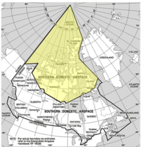
Fig. 1 – http://www.NavCanada.com
2.1.2. ICAO
The French Academy for Air and Space has launched an initiative to see what could be done to achieve the change at ICAO level. NAV Canada already hosted an ICAO webinar on the subject to share their view and information to ICAO members.
2.1.3. According to the ICAO working paper A41-WP/567 and the state letter two primary issues support the switch.
2.1.3.1.Significant Cost to Maintain the Magnetic System
2.1.3.1.1.ICAO has an online assessment tool to see the impact to compare today’s magnetic values with to the future estimates – with the tool it is possible to estimate how much the magnetic shift will affect the navigation aids. The tool can be found on ICAO’s True North section at: https://www.icao.int/safety/OPS/OPS-Section/Pages/Truenorth.aspx
2.1.3.1.2.Conflicting values between databases and procedures also add to the complexity.
2.2. North Reference
2.2.1. True North
Royal Museums Greenwich gives the following explanation of the True North, “True North (also called Geodetic North or Geographic North) is the direction that points directly towards the geographic North Pole. This is a fixed point on the Earth’s globe.”
2.2.2. Magnetic North
Magnetic North is the direction that a compass needle points to as it aligns with the Earth’s magnetic field.
2.2.3. Grid North
According to WorldAtlas “Grid North is a navigational phrase used to refer to the northward on a grid lines in a map projection. Grid North contrasts the true north and the magnetic north in that it is aligned to grind lines and always points upwards on a map.”
2.2.4. Geographic North Pole
According to National Geographic the Geographic North Pole is the northernmost point on Earth. It is the precise point of the intersection of the Earth’s axis and the Earth’s surface.
2.2.5. Magnetic North Pole
Polarpod describes the Magnetic North Pole as the point where the lines of force of the Earth’s magnetic field converge. This is the point that attracts the needle of a compass. The Magnetic North Pole is continually moving.
2.2.6. Magnetic Variation/Declination
The lines of the magnetic field vary in direction when compared to the meridians. This difference between True Direction and Magnetic Direction at any point on the Earth is known as Magnetic Variation.
Due to the movement of the magnetic poles, variation values are not constant. This means charts need updating every few years.
2.2.7. Movement of the Magnetic North Pole
According to the European Space Agency (ESA) movement of the Magnetic North Pole has been known since 1831, since its first measurement. It has been noticed to be drifting from the Canadian Arctic towards Siberia. Between 1990 and 2005 its speed accelerated from 0-15 kilometers a year to the present 50-60 kilometers a year.
Two large-scale lobes of negative magnetic flux on the core have determined the location of the Magnetic North Pole over the last two decades. Present models show that the Canadian lobe is becoming longer, thus weaker. This is causing the Pole to move towards Siberia at a higher speed.
2.2.8. The World Magnetic Model
The World Magnetic Model (WMM) is the standard model for navigation, altitude, and heading referencing systems using the geomagnetic field. Additional WMM uses include civilian applications, including navigation and heading systems. The model is produced at 5-year intervals, with the current model expiring on December 31 2024.
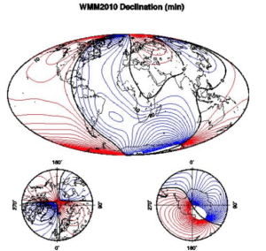
Fig. 2 – https://en.wikipedia.org/wiki/
2.3. Air Navigation
2.3.1. Inertial Navigation
SKYbrary defines inertial navigation as “a form of dead-reckoning that relies on accelerometers and gyroscopes to detect acceleration and velocity respectively along 3 perpendicular axes. An approximate of 2 or 3 dimensional position can be constantly determined in relation to a known starting point, velocity and orientation.” It is also mentioned that if the latitude is known, it is able to align with True North.
Inertial Reference Unit aircraft would bypass current magnetic variation tables.
2.3.2. Attitude and Heading Reference System
AHRS combines acceleration gyro information with heading data provided by the flux detector.
AHRS normally operates in Magnetic Mode, but also Directional Gyro Mode can be selected.
Flux detector senses the Earth’s magnetic field and corrects the heading information accordingly.
However, newer versions of AHRS, eg. AHS-4000, are equipped with inertial grade instruments instead of flux detectors. This means that the AHRS senses true heading and uses an internally stored World Magnetic Model to provide Magnetic Heading data.
AHRS aircraft with flux valves would need to update to Micro-Electro Mechanical System, Fibre Optic Gyro technology or low-cost DO178 heading converters.
2.3.3. Directional Gyro and Magnetic Compass
Read the magnetic compass (and/or runway heading), adjust for Magnetic Variation and set the adjusted heading on the directional gyro. Cost effective heading converters are also available which automatically convert system heading from magnetic to true.
2.4. Ground Based Navigation
2.4.1. ILS/LOC
According to Skybrary the Instrument Landing System (ILS) is defined as:
“a precision runway approach aid based on two radio beams which together provide pilots with both vertical and horizontal guidance during an approach to land.”
Académie de l’air et de l’espace (AAE) states that:
“an ILS approach may be flown using magnetic or true reference, with no change in the ground infrastructure or aircraft receiver. The only condition is to use the same reference (magnetic or true) for the localizer course and for heading.”
AAE continues that using magnetic reference can introduce some systemic error due to discrepancies between published magnetic variation and variation used by navigation system (IRS or GNSS) or between published variation and actual variation for aircraft using magnetic heading only. If this error is significant, it can cause lateral instability.
EASA’s Airworthiness Directive AD 2003-270 B for Airbus A32S states that:
“a difference greater than 3° between the real magnetic deviation and the one implemented in the inertial reference system could lead to an unsafe situation during the phases of CAT 2 or CAT 3 automatic landing and roll out.”
Only the track value in the database would need to be changed in order to be able to use ILS/LOC in true reference.
2.4.2. NDB
Skybrary describes the Non-Directional Beacon (NDB) as a radio beacon that operates in the MF or LF bandwidths. NDB´s signal is transmitted with equal strength to all directions.
NDB’s can be used in magnetic or true reference without any updates to the beacon itself.
2.4.3. VOR
Skybrary:
“VHF Omnidirectional Radio Range (VOR), is an aircraft navigation system operating in the VHF band. VOR’s broadcast a VHF radio composite signal including the station’s Morse code identifier, and data that allows the airborne receiving equipment to derive the magnetic bearing from the station to the aircraft. This line of position is called the radial. Alternatively, the VOR radial may be combined with magnetic heading from the aircraft compass to provide a bearing relative to the aircraft axis, which can be used to home to the beacon. VOR beacons are frequently used as waypoints on conventional airway systems, or as the basis for a non-precision approach.”
AAE states that:
“VOR stations must be periodically calibrated and their signal aligned with magnetic north, due to magnetic variation evolution”. Also, “Use of VOR in true reference will require to rotate their signals in order to be used in true reference (this will be a one-time operation, contrasting with periodic rotation required by magnetic variation evolution).”
2.5. Procedures
2.5.1. Charts
ICAO Annex 4, Aeronautical Charts, 11th Edition, as it is, states multiple times, regarding different types of charts (example taken from Chapter 7, Enroute Charts):
“Bearings tracks and radials shall be magnetic, except as provided for in 7.8.2. Where bearings and tracks additionally provided as true values for RNAV segments, they shall be shown in parenthesis to the nearest tenth of a degree, e.g. 290° (294.9°T).”
7.8.2. Is a recommendation:
“In areas of high latitude where it is determined by the appropriate authority that reference to Magnetic North is impractical, another suitable reference, I.e. True North or Grid North, should be used.”
Furthermore, 7.8.3. States:
“Where bearings, tracks or radials are given with reference to True North or Grid North, this shall be clearly indicated. When Grid North is used, its reference grid meridian shall be identified.”
2.5.2. Instrument Flight Procedures
All Instrument Flight Procedures are designed in TRUE. Magnetic Variation is incorporated as the last part of the design process.
2.5.3. Airports
NAV Canada and IAIN also investigated the airport impact. They analyzed 25732 hard-surface runways worldwide. 14416 would need to be renumbered in True. 5656 are currently out of magnetic alignment.
However, renumbering runways could be done over a period of time. Already today many runways are out of magnetic alignment and in case of multiple (more than three) parallel runways all of them cannot be magnetically aligned, since only Left, Right and Center can be used. The period of time should be carefully described, otherwise some states could just ignore the renumbering.
ICAO Annex 14, Aerodromes, 9th Edition states:
“On a single runway, dual parallel runways and triple parallel runways the two-digit number shall be the whole number nearest the one-tenth of the magnetic North when viewed from the direction of approach. On four or more parallel runways, one set of adjacent runways shall be numbered to the nearest one-tenth magnetic azimuth and the other set of adjacent runways numbered to the next nearest one-tenth of the magnetic azimuth.”
Airport Improvement magazine (October 2014) has an article (by Victoria Soukup) about runway redesign action at John Wayne airport KSNA in Orange County, California. Renaming runways 1L-19R and 1R-19L to 2L-20R and 2R-20L. Total cost of the project was about USD 885.000. FAA paid for 81% of it.
Quebec City International Airport in Canada (CYQB) had to renumber their runway 12/30 to 11/29 in 2013. Only the material costs were USD 10.000. Work itself and salary costs are not included. Estimated costs for the whole project are around USD 75.000. Since it took place over 10 years ago, prices have certainly doubled.
Finavia Finland informed that they have not made exact calculations of such a project. However, they gave an estimate saying that the ultimate cost of renumbering one single runway would definitely be more than EUR 100.000.
2.5.4. Wind Data
According to ICAO Annex 3 Meteorological Service for International Air Navigation wind direction shall be reported in degrees true in METAR. SKYbrary mentions, that magnetic is used in ATIS. Also, when the air traffic controller reports the surface wind to a pilot, magnetic direction is used.
Using two references increases the risk of error, especially when the margins are small. Although the difference is not necessarily as big as between different units of measurement (for example fuel calculations pounds vs. liters, “Gimli Glider”), it can lead into dangerous situation in a quickly changing environment. Correct data is essential to calculate short field take-off/landing distance. This is mentioned for example in a report by the Dutch Safety Board. Eg. KLM B738 at Amsterdam on June 10, 2018. Although this report describes the error being the runway length, wrong wind data could lead into similar situation.
2.6. Transition
2.6.1. AAE recommends, that the transition should be done regionally and in a coordinated way. ICAO would be the best way to set up the coordination, like it was done for the RVSM transition.
AAE states, that:
“Procedures should be established to fly from a region where the reference is true north to a region where the reference is magnetic (or back), in particular if the magnetic variation is significant.”
AAE also recommends, that the Canadian experience should be examined, since their flights operate daily between the South Domestic Airspace (Magnetic reference) and the North Domestic Airspace (True reference).
2.6.2. Global transitions have already been experienced, for example during the introduction of RVSM airspace. These experiences should be taken into account while deciding how to change from magnetic to true reference. When Russia transitioned into standard ICAO flight levels in feet, clear procedures with neighboring units were made: Level off zone – 5 minutes of level flight between Russia and Mongolia. For example, an eastbound flight from Russia to Mongolia will be at FL370. Around 10 minutes prior to entering the Mongolian airspace, the Russian controller will climb the flight to FL371 – 11.300 meters. The aircraft will be at the new meter flight level for at least five minutes. A westbound flight would maintain eg. FL 11.600 meters and the Russian ACC would change the level clearance to FL380 only five minutes after the border.
Conclusions
3.1. Aerial navigation is currently based on Magnetic North, except in Polar Areas close to the Magnetic North Pole where True North is used as reference.
3.2. The movement of the Magnetic North Pole creates the need for data and infrastructure updates, i.e. magnetic variation databases, charts, runway designators and VOR beacons. It is not cheap.
3.3. Databases are not necessarily up-to-date and there can be differences to published values. This creates a safety risk.
3.4. Global changes, for example the introduction of RVSM airspace, have been experienced. They should be examined, and the results put into use when switching from magnetic to true. Piecemeal changeover to True North from Magnetic North is undesirable.
Recommendations
4.1. It is recommended to accept this working paper as information material.
References
ICAO Annex 3 Meteorological Service for International Air Navigation, 20th Edition.
ICAO Annex 4 Aeronautical Charts, 11th Edition.
ICAO Annex 14 Aerodromes, 9th Edition.
SKYbrary.
NAV Canada.
Finavia.
ESA, European Space Agency.
AAE, Académie de l’air et de l’espace.
EASA, the European Aviation Safety Agency.
Royal Museums Greenwich http://www.rmg.co.uk.
National Geographic.
Navigation for Pilots, Paperback Edition 2005, Jim Hitchcock.
IAIN, International Association of Institutes of Navigation.
WorldAtlas.
State Letter AN 11/57-22/87 Supporting Document 2.
Airport Improvement Magazine October 2014.
Wikipedia.
AIP Mongolia.
Dutch Safety Board Report KLM B738 at Amsterdam on June 10 2018.

