54TH ANNUAL CONFERENCE, Sofia, Bulgaria, 20-24 April 2015WP No. 84Introduction to GNSS Landing SystemsPresented by TOC |
Summary
GNSS has great precision but not enough for approach purposes. Augmentation systems can get over this limitation. Ground Based Augmentation System (GBAS) and Satellite Based Augmentation System (SBAS) are described in the jointly with their advantages and limitations.
Introduction
1.1 The aviation community has been used to the ILS (Instrument Landing System) for many years as a reliable system to perform the final approach phase of the flight. But ILS is relatively expensive to deploy and maintain, especially due to the need of regular calibration flights.
1.2 The first Global Navigation Satellite System (GNSS), was the American Global Positioning System (GPS) which has been fully operational for more than 20 years and is widely used for en-route purposes. But the features of GNSS as first designed are not suitable for the approach phase of flight.
1.3 Augmentation systems have been designed to improve the features of GNSS making the system able to support approach and landing operations. First CAT I operations have been already developed and implemented and future developments try to achieve CAT III operations.
Discussion
2.1 ILS has prevailed as the standard for the final phase of flight over more technically advanced systems such as MLS (Microwave Landing System). The availability of GNSS has made it possible to think on its use as a substitute of ILS with several advantages, though the primary incentive would be cost savings; no ground infrastructure would be needed making a GLS (GNSS Landing System) able to serve any runway at any place, at least from a theoretical point of view. This reduced requirement of ground based infrastructure greatly reduces the cost of maintenance compared to one ILS system, and even more so for airports with multiple ILS installations.
2.2 GNSS alone is not suitable to the final approach phase of flight. Its precision, though impressive for en-route navigation, is not enough for a landing system. Another issue is that unlike ground based systems, GNSS errors can change over a period of hours due to satellite movements and the effects of the ionosphere.
2.3 The Integrity problem is also to be considered: “Health” status for every satellite are part of the message received from GNSS constellations. In the GPS case the full navigation message takes 12.5 minutes to transmit and is updated twice a day. The notification of a failed satellite would take too long compared to CAT III system which allows only 2 seconds from when a system goes out of tolerance until the spare transmitter is on the air.
2.4 Augmentation systems are designed to compensate the errors mentioned in 2.2, thus increasing the precision, and monitor the system to improve its integrity. Annex 10 defines three augmentation systems: Aircraft-Based Augmentation System (ABAS), Satellite-Based Augmentation System (SBAS) and Ground-Based Augmentation System (GBAS).
2.5 Description of GBAS
2.5.1 The idea behind GBAS is to measure the small but significant deviations in the calculation of a position using the GNSS satellite signals, calculate corrections and send them to the aircraft.
2.5.2 A GBAS Ground Facility typically has three or four GNSS antennas, situated at positions with perfectly determined coordinates. The position calculated for these antennas by the use of GNSS is sent to a central processing system which compares them with the known real positions and determines a correction factor in case any difference is found. Corrections are sent to the aircraft via VHF Data Broadcast (VDB) in the 108.025 – 117.975 MHz band. Another function of the GBAS Ground Facility is to monitor general satellite performance thus preventing the aircraft to use a faulty satellite. Finally, GBAS also broadcast precision approach pathpoints data.
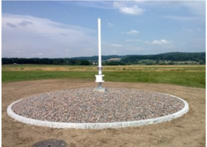
Reference GBAS antenna in Zurich, Switzerland
2.5.3 According to the Annex 10 up to 256 types of messages may be broadcasted by the GBAS Ground Facility broadcast to transmit the information described in 2.5.2. At present only three different types are specified while the rest are reserved or not yet defined.
- The message type 1 (MT1) sends up pseudo-range corrections for up to 18 individual satellites. Two MT1 can be linked making possible to broadcast corrections for up to 36 satellites. For precision approaches the aircraft GBAS receiver only uses satellites for which corrections are available, meaning that no correction broadcasted for a satellite in line of sight is equivalent to a “do not use this satellite” message thus improving the integrity of the system.
- The message type 2 (MT2) contains information related to the Ground Facility station such as the coordinates of the reference point to which all corrections refer. It also include the maximum distance at which the corrections may be used, data for tropospheric correction and local magnetic variation.
- The message type 4 (MT4) contains the Final Approach Segment (FAS) data. Included are the airport identification, runway designator, landing threshold point coordinates, threshold crossing height, flight path alignment point and glide path angle. All the approaches served by the GBAS facility must be broadcasted at least once every ten seconds. The system admits up to 48 different approaches.
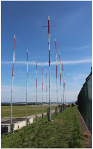
VHF antennas of the Zurich GBAS
2.5.4 At present GBAS approaches are ILS-like approaches defined by a straight line linking a final allignment point (FAP) with the landing threshold point. It is envisaged the capability to perform curved approaches, called Terminal Area Path (TAP) by the FAA. Some flight tests have been performed but there are no SARPs in the Annex 10 yet nor an autopilot capable of performing the automatic procedure which shall be a requirement considering the complexity of this kind of procedure.
2.5.5 GBAS avionics standards have been developed to mimic ILS to simplify the integration of GBAS with existing avionics and reduce aircrew training requirements. The industry has even developed a multi mode receiver (MMR) comprising several receivers (VOR, ILS, GNSS) in one box.
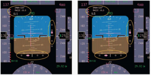
A pilot barely finds any difference between an ILS and GBAS approaches
2.5.6 Although the CAT I/II/III terminology is commonly used, a new concept called GAST (GBAS Approach Service Type) is intended for future SARPS designation. Using this terminology GAST-C is the equivalent to CAT I while GAST-D is the equivalent to CAT III.
2.6 Benefits and issues of GBAS
2.6.1 ILS signal can be disturbed due to the presence of objects in determined areas defined as critical and sensitive by ICAO in the Annex 10. The creation of such areas produces an operational impact due to departing aircraft holding relatively far from the runway to avoid interference. GBAS does not use antenna patterns to compose the navigation signal so the site constraints are related to signal blockage and multipath effects reducing the operational impact.
2.6.2 GBAS is intended to permit the use of guided curved approaches. This feature can be useful to create procedures to avoid aircraft flying over specific areas due to noise reasons or even to avoid obstacles. It could also allow for more efficient use of airspace in areas with multiple airports close by.
2.6.3 The information provided by GBAS may be used to support PBN in the terminal area.
2.6.4 A single GBAS can broadcast up to 48 approaches to different runways in different airports in the vicinity (approximately a 23 nautical miles radius). In the same way GBAS can define different glide angles for the same runway allowing different paths for each kind of aircraft.
2.6.5 GBAS can also be quickly configured to support a new threshold in case it must be displaced while ILS needs to be physically moved to comply with a new position.
2.6.6 GBAS can provide guidance during a missed approach.
2.6.7 The estimated cost of a GBAS facility is approximatively twice the cost of a single ILS but the ILS defines only one approach while a GBAS can define up to 48 approaches to different runways. The maintenance costs is estimated as half of that of an ILS.
2.6.8 Probably the most important issue affecting GBAS and GNSS in general is space weather. The effect of disturbances in the ionosphere on the satellite signals can lead to positioning errors and even the interruption of service. These undesirable effects are more prominent in low latitudes. In July 2011 a Honeywell SLS -4000 SmartPath GBAS station was acquired and installed in Rio de Janeiro Airport (SBGL) to evaluate the behaviour of a station that operates normally in mid-latitudes airports like Bremen (Germany), Newark (USA), Málaga (Spain) or Sydney (Australia). The station demonstrated sensitivity to ionospheric caused disturbance which affected service availability.
2.6.9 Future multi-constellation multi-frequency GNSS receivers are expected to mitigate the ionospheric issues but solar storms may produce sudden peaks of activity in the ionosphere causing disturbances to the GNSS system. An example is the series of solar storms in late October 2013 that degraded GPS performance. An eventual intense solar flare reaching the Earth could potentially degrade GNSS performance leading GBAS to be out of service. An aircraft could find all GBAS equipped airports in its range unable to provide such an instrumental approach service.
2.7 Current situation and future evolution
2.7.1 According to the ICAO Global Air Navigation Plan (GANP) GBAS CAT I operations belong to Block 0 meaning that they are currently in place in some place of the world. GBAS CAT II/III belong to Block 1 meaning that this kind of operations should be implemented by 2018. The GANP recognizes that until there are GBAS CAT II/III standards, GLS cannot be considered a candidate to replace ILS. A draft SARPs amendment for GBAS to support CAT II/III approaches is completed and currently undergoing validation by States and industry.
2.7.2 As of 2012 approximately 40 GBAS stations around the world were supporting testing and CAT I operations and the system has grown to be already operational in several airports. While promising the concept shows that it still needs some development. In Sydney for example the ionosphere disturbances have made the system unusable sometimes. In Frankfurt a whole series of NOTAM were issued describing limitations to the system.
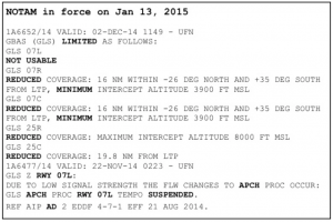
NOTAM with limitations to GBAS operations in Frankfurt
2.7.3 While GBAS is intended to be the new standard approach and landing system, it may be a long time until the aircraft fleets are equipped thus making the ILS irreplaceable for many years. As an example only the A380 and B748 planes in the Lufthansa fleet are equipped, this is a 10% of its fleet. On the other hand some airlines are already prepared: Airberlin fleet of B737 for example is fully equipped. The German provider DFS estimates that fleet equipment will make possible to switch off some of their ILS by 2030.
2.7.4 The next step in GBAS evolution will be to extend the system to take advantage of multiple frequencies and multiple constellations. Use of multiple frequencies will allow more robust monitoring and detection of errors caused by ionospheric anomalies. Use of multiple constellations will enable higher availability of robust geometries that are required to support CAT II/III operations and mitigate common mode errors.
2.7.5 GAST-C and GAST-D (see 2.5.6) are currently being developed jointly with other two approach services for Approach with Vertical Guidance (APV). The total number of Approach Service Types intended to be developed is six:
- GAST-A: for operations to APV I performance
- GAST-B: for operations to APV II performance
- GAST-C: for operations to CAT I performance level
- GAST-D: for operations to CAT III performance
- GAST-E (TBD): either CAT II performance or L5/E5 CAT III
- GAST-F (TBD): planned for multi-constellation, multi-frequency CAT III performance level
2.7.6 In October 2014 simulations were run in EUROCONTROL premises in Bretigny, France. According to the preliminary results the runway capacity of an airport using a GBAS system is incremented due to the reduction of protection areas as expected (see 2.6.1) even in cases were GBAS coexist with ILS. On the negative, an increment in the controllers workload was noted due to the need to accommodate planes using two different approach systems thus making the tower controller constantly check the equipment of the landing planes to know if they needed the protection areas to be cleared of intruders or not.
2.8 The SBAS alternative
2.8.1 SBAS works in a similar way to GBAS but on a regional basis. Instead of a single ground station there is a net of reference ground stations which monitor the GNSS signals in a similar way to GBAS. Corrections are sent to the aircraft through geostationary satellites jointly with integrity information broadcasted as a “do not use” message when a faulty satellite is detected or a “not monitored” for satellites not visible to any monitoring station.2.8.2 The information sent by the SBAS satellites is broadcasted using the GNSS frequencies. The satellites include not only the possibility to relay SBAS information, but a GNSS payload so they are themselves GNSS satellites thus improving the availability of the GNSS.
2.8.2 Unlike GBAS the SBAS do not need any infrastructure in the airports served by the system.
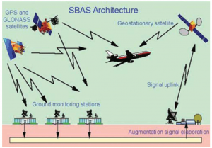
2.8.3 There are several SBAS already in use. The American system, WAAS, uses 38 reference stations in the USA, Canada and Mexico; the European EGNOS has 39 stations while the Japanese MSAS needs only 4 and the Indian GAGAN uses 15. It is expected that the Russian system SDCM reaches operational status in 2015.
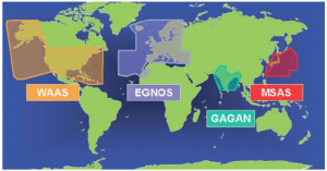
2.8.4 WAAS was the first operational SBAS. It was expected that 250 ft would be the lowest decision height meaning that it would not be used for precision approaches but experience demonstrated that this assumption was conservative. The FAA claims that a service equivalent to ILS CAT I can be provided.
2.8.5 Being GNSS based, SBAS is as vulnerable as GBAS to ionospheric interference or even more because it is more satellite dependant. Thus, the drawbacks related to space weather affecting GBAS exists for SBAS.
2.9 Changes for ATCOs
2.9.1 A GNSS-based approach is very similar to an ILS one making the switch to this new kind of procedure very easy to controllers. New phraseology has been developed. Chapter 12 of ICAO Doc 4444 reflects this:
- The new types of approach are recognized being they named “GBAS Approach and SBAS Approach”.
- The usual references to Localizer and Glide Path used for ILS approach have an equivalent in GBAS and SBAS approaches. The term used is Approach Course.
2.10 The following policy may be related to this subject:
2.10.1
| ATS 3.14 MIXED MODE OPERATIONS
Mixed mode operations are defined as ATM Operations that require different procedures due to variances in airspace users’ characteristics and/or ATM design within the same area of controller responsibility. Efforts should be undertaken to reduce existing Mixed Mode Operations by creating intrinsically safe solutions. Introductions of new Mixed Mode Operations should be avoided by creating intrinsically safe solutions. When safety of a Mixed Mode Operation cannot be completely managed at an intrinsic level, assessment must take place that the change in the ATM system does not increase controller workload to an unacceptable level. |
2.10.2 Implementing a new system like GLS while having still in place the previous one, ILS, leads to the need of Mixed Mode Operations. The policy on the subject is considered by the TOC as valid and solid.
2.10.3 While there is no GLS policy in the Technical and Professional Manual there is a policy on advanded approach procedures that was found as outdated by the TOC. The revision of this old policy is intended for the next year working program.
Conclusions
3.1 GNSS has excellent features for en-route navigation but neither its precision nor its integrity are enough for precision approach purposes thus augmentation systems are required for that phase of flight.
3.2 GBAS is based on measuring the GNSS satellites signal in determined places to calculate corrections and send them to the aircraft in the vicinity of the GBAS facility thus improving both precision and integrity.
3.3 At present GBAS approaches are limited to ILS-like CAT I. In a future CAT III is expected and even guidance on the ground as well as curved approaches.
3.4 Other benefits of GBAS include less restrictions due to protection of the signal, more flexible configuration and reduced maintenance cost than than ILS and possibility to use up to 48 approaches to different runways, even at multiple airports within the range of a single facility. Drawbacks are mainly related to the effect of disturbances in the ionosphere specially in low-latitudes.
3.5 Preliminary tests confirm that the use of GBAS approaches increases the runway capacity due to the reduction of protection areas being the drawback an increase in the tower controller workload due to the need to accomodate the situation to traffic performing GLS and ILS approaches, thus leading to a mixed-mode operation. The GBAS stations already in use have shown promising results but also some limitations.
3.6 Due to fleets not being equipped yet ILS may still be in place in airports also equipped with GBAS even until 2030 and beyond.
3.7 A similar augmentation system is SBAS. It uses a network of regional ground stations to calculate corrections and broadcast them to aircraft via geostationary satellites.
3.8 Several SBAS are in use to provide augmentation in large areas: WAAS in North America, EGNOS in Europe, MSAS in Japan, etc.
3.9 SBAS may allow a service equivalent to ILS CAT I with no need of any facility in the vicinities of the aerodrome served.
3.10 IFATCA Policy concerning advanced approach systems is outdated and is intended for revision.
Recommendations
It is recommended that:
This paper is accepted as information material.
References
ICAO Doc 9750 – AN/963 Global Air Navigation Plan.
ICAO Doc 9849 – AN/457 Global Navigation Satellite System (GNSS) Manual.
ICAO Guide for Ground Based Augmentation System Implementation. May 2013.
ICAO Annex 10.
ICAO SAM/IG/14-WP20 Status of Low-Latitude Ionosphere Threats Model for GBAS.
Albert Helfrick: Principles of Avionics, 6th edition; Avionics Communications Inc. 2010.
Paul M. Kintner Jr., Todd Humphreys and Joanna Hinks: GNSS and Ionospheric Scintillation; Inside GNSS. July/August 2009.


