
DISCLAIMER
The draft recommendations contained herein were preliminary drafts submitted for discussion purposes only and do not constitute final determinations. They have been subject to modification, substitution, or rejection and may not reflect the adopted positions of IFATCA. For the most current version of all official policies, including the identification of any documents that have been superseded or amended, please refer to the IFATCA Technical and Professional Manual (TPM).
63RD ANNUAL CONFERENCE, Singapore, 15-19 April 2024WP No. 95Space Based Communication and Surveillance
|
Summary
Investigating updates on Space Based solutions for Air Traffic Management. The purpose of this working paper is to look into communication and surveillance utilizing satellites, finding out advantages while looking at possible negative impacts.
1. Introduction
1.1. There are multiple ongoing projects to utilize Space Based technology for Air Traffic Management (ATM).
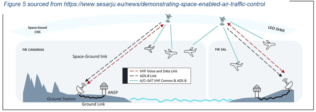
1.2. The idea is to create global coverage for VHF Aeronautical Mobile Satellite Service voice, data communications and ADS-B surveillance with Low Earth Orbit (LEO) satellites.
1.3. This could help to optimize ATM over Oceanic and remote areas.
1.4. The IFATCA’s Technical and Operations Committee (TOC) received a job card about Startical, one of the ventures. Most of the examples in this working paper are based on it.
1.5. Space-Based ADS-B surveillance is covered in an existing IFATCA working paper, WP No. 87 (Gran Canaria, 2014) and a policy was created based on it. The topic is very much linked to this working paper, since companies planning to provide Space-Based voice and data communications also include ADS-B surveillance data in their products.
2. Discussion
2.1 Space
2.1.1 Low Earth Orbit
The European Space Agency (ESA) describes the Low Earth Orbit as “an orbit that is relatively close to Earth’s surface.” Normally it refers to an altitude between 160 km up to 1000 km.
ESA continues by explaining that LEO satellites, unlike Geostationary (GEO) satellites, do not necessarily have to follow a particular path, they can be tilted. That gives them more route possibilities which is one reason why LEO satellites are common.
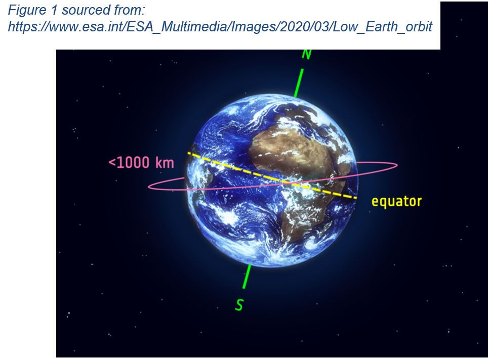
Normally LEO satellites are not optimal for telecommunications due to their high speed, approx. 7.8 kilometers per second (16 times around the Earth per day). However, a constellation of LEO satellites creates a net around the Earth and gives constant coverage.
2.1.2 Satellite Constellation
The International Astronomical Union (IAU) describes a satellite constellation as follows, “A satellite constellation is a number of similar satellites, of a similar type and function, designed to be in similar, complementary, orbits for a shared purpose, under shared control. Constellations are used for navigation and geodesy (e.g. GPS, Galileo and GLONASS), satellite telephony (e.g. Iridium), or Earth Observation (e.g. DMC, PlanetLabs). More recently, companies are planning large scale constellations in low- and mid-Earth orbits to provide global satellite internet, or Internet of Things to connect machis and systems together directly. A constellation with thousands of individual units at low altitude reduces the signal latency (i.e. the time taken to signals to move from a ground station providing internet to the satellite and then on to a user), while maintaining high levels of coverage especially in remote areas without developed ground infrastructure. While there are currently around 2000 active satellites orbiting Earth, the planned satellite constellations could increase this number by tens of thousands in the coming decades.”
In their statement on 12 February 2020, IAU also expressed concerns about possible negative impacts on astronomical observations and appearance of the night sky. While the statement concentrates on optical wavelengths, it also mentions that there might be consequences also on radio and submillimeter wavelength ranges, which are under investigation.
2.1.3 Nanosatellite
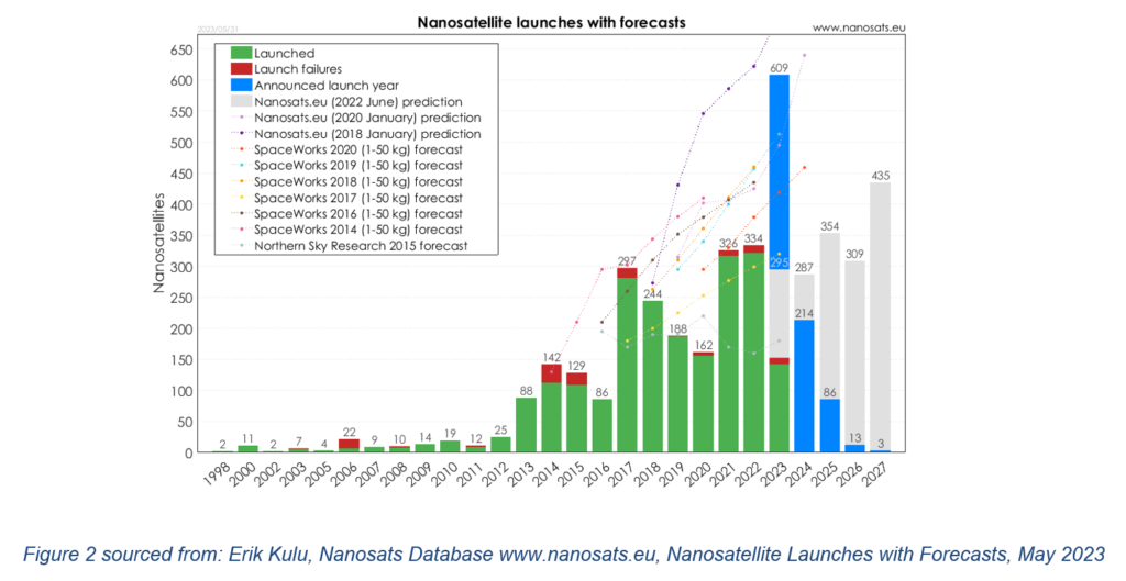
According to Nanosats Database a nanosatellite, in strict terms, is any satellite with a mass from 1 to 10 kg. The same database states that by 31 May 2023 over 2200 nanosatellites were launched.
2.1.4 Space Weather
The National Aeronautics and Space Administration (NASA) explains Space Weather as follows, ”The term “space weather” was coined not long ago to describe the dynamic conditions in the Earth’s outer space environment, in the same way that “weather” and “climate” refer to conditions in Earth’s lower atmosphere. Space weather includes any and all conditions and events on the sun, in the solar wind, in near-Earth space and in our upper atmosphere that can affect space-borne and ground-based technological systems and through these, human life and endeavor.” (Eddy, 2009)
2.1.4.1 According to the Australian Space Weather Forecasting Centre Solar events can interfere with both, HF and VHF radio communications,
“The variation of the solar ultra-violet flux during the solar cycle results in changes in the range of frequencies available to HF communications. Also, X-rays during solar flares produce short wave fadeouts, often preventing HF communications. Ionospheric storms also affect HF communications by reducing the available band of frequencies and degrading their quality.
Solar radio bursts can interfere with VHF and UHF signals in the sunlit hemisphere of the Earth. Communications satellites using this frequency band are also affected by solar interference, especially around equinox (March and September) when the satellites are close to the direction of the Sun, at times during the day.”
2.1.4.2 Severe space weather poses a risk to aviation according to an IFATCA policy that can be found in AAS 1.17, Space Weather. The policy mentions four bullet points on appropriate risk mitigation, of which one calls for “contingency procedures for the cases where space weather negatively affects communication, navigation and/or surveillance systems.”
2.1.5 Space Debris
In 2021 over 27.000 pieces of debris were tracked by the American Department of Defense’s Space Surveillance sensors. The number does not include debris that is too small to be tracked. However, even the smaller pieces are a threat due to their speed. NASA explains that debris includes both human-made objects orbiting the Earth that do not serve a useful purpose anymore, and natural meteoroids orbiting the Sun. The amount of debris is constantly increasing. In 1995 the National Academy of Sciences of the USA published a technical assessment on orbital debris. The assessment reported the current hazard to be fairly low, but predicted it to increase to a level that would seriously jeopardize safety in some orbital regions.
2.1.6 Hostilities
There is always a possibility of hostile actions by governments or criminal actors. Interfering with satellite communications does not require physical force.
2.1.6.1. Jamming means transmitting a strong signal and overriding signals at the receiver.
2.1.6.2. Spoofing means trying to deceive a receiver by broadcasting false signals, structured to resemble normal signals.
2.1.6.3. Both methods have already been used against Global Navigation Satellite System (GNSS) and it is an actual risk for space-based ATC.
2.1.7 Joint Position Paper by IFALPA and IFATCA
2.1.7.1 In December 2023 International Federation of Air Line Pilots’ Associations (IFALPA) and IFATCA published a position paper 23POS25. The paper mentions that aircraft are becoming more reliant on space-based signals but in recent years there have been thousands of occurrences of partial or complete loss of the signals.
2.1.7.2 In the position paper it is mentioned that satellite signals are very weak when they reach the receiver. It makes them vulnerable to natural and artificial interference.
2.1.7.3 Problem has been recognized at the ICAO level. At the 41st session of the ICAO assembly in October 2022 three different papers brought up the concern: WP/97 by Czechia, WP/196 by the UAE and WP/198 by Japan.
2.1.7.4 The position paper urges states to establish the necessary legal framework and act upon harmful, illegal interferences. The States should also assess the risks associated with conflict zones and make sure that the necessary information is shared to relevant parties during civil or military testing and other activities. Also, fuel planning should take signal outage into consideration and approach procedures should not be based only on satellite navigation.
2.1.7.5 According to the position paper there are methods to improve GNSS resiliency, for example: independent networks, appropriate interference protection, detection, mitigation and reporting capabilities and a review or development by ATS units and operators of capabilities to mitigate safety hazards from signal disruptions.
2.2 North Atlantic Tracks
2.2.1. As an example of a remote airspace, we can look into development of ATC over the North Atlantic to understand what kind of advantages Space-Based surveillance and communications could possibly bring.
2.2.2. The Pacific Organized Track System (PACOTS) is similar to the North Atlantic Organized Track System (NAOTS) and is not researched separately for this working paper.
2.2.3. The nature of ATC over the North Atlantic is more strategic than in any other busy airspace. In 2018, pre-pandemic, over 500.000 flights crossed the Atlantic. Although improving technology, like CPDLC and Space-based ADS-B have supported the traffic growth, operating over the ocean is still very different compared to airspace with surveillance and VHF voice coverage available.
2.2.4. An organized track system across the North Atlantic (NAT) was introduced for commercial shipping as early as in 1898. After World War II, air traffic crossing the Atlantic increased, causing separation difficulties for ATC. The first use of NAT tracks took place in 1961. Starting in 1965 tracks were published daily and controllers could clear aircraft to fixed tracks to be able to separate them by longitudinally, vertically and laterally. In 2006 CPDLC became the primary communications method, overtaking HF radio. In March 2019 NAV Canada and NATS started to use the space-based ADS-B surveillance over the Ocean, which eventually reduced the longitudinal separation from 40 NM to 14-17 NM and lateral separation from 23 NM to 15 NM.
2.2.5 North Atlantic Tracks are published twice a day and take into account shifting of the jet stream and the traffic flow.
2.2.6. It is also possible to file a route that does not follow a NAT track. However, reroutings and altitude changes are then more likely. Most operators choose to plan on a track.
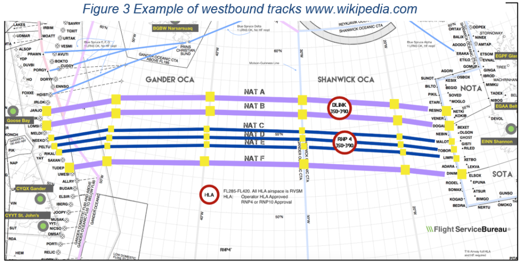
2.2.7. Although the routes change daily, there is a list of fixed entry and exit points linking the routes into the North American and European airspace.
2.2.8. Westbound tracks (valid 1130-1900 UTC) are named with a letter from A to M (I excluded), A being the northernmost.
2.2.9. Eastbound tracks (valid 0100-0800 UTC) are named from Z down to N (O excluded), Z being the southernmost.
2.2.10. A route that doesn’t follow a predefined track, must have a waypoint every 10 degrees of longitude.
2.2.11. Under certain circumstances aircraft could be allowed to join an outer track halfway. That depends on the traffic flow and when it is not possible due to separation, then the aircraft will be rerouted north or south of the OTS tracks.
2.2.12. In the NAT high level airspace any level can be planned, meaning that the ICAO standard direction cruising levels do not have to be followed.
2.2.13. Oceanic Clearance must be requested from the Oceanic Center with the expected time over the planned Oceanic entry point (OEP). If the requested track is not available at that time or altitude, an alternate track, altitude or speed will be assigned.
2.2.14. Aircraft are not allowed to change the assigned track, speed or altitude without clearance.
2.2.15. ADS-C equipped aircraft downlink automatic reports to the Oceanic Control Centers. CPDLC/HF position reports are then not required. However, SELCAL check has to be done when entering the Oceanic Airspace and after a frequency change (normally happening at 30W). This is done to ensure a functional backup.
2.2.16. In June 2004 the Strategic Lateral Offset Procedure was introduced. It spreads out the traffic and reduces the risk of a collision during unusual events.
2.3 Environment
2.3.1 The ICAO member states have agreed to collaborate on three environmental core fields: Climate change and aviation emissions, aircraft noise, and local air quality.
2.3.2 The ICAO Resolution A41-21 from the 41st session of the ICAO Assembly notes that, “…to promote sustainable growth of international aviation and to achieve its global aspirational goals, a comprehensive approach, consisting of a basket of measures including technology, sustainable aviation fuels, operational improvements and market-based measures to reduce emissions and possible evolution of Standards and Recommended Practices (SARPs), is necessary.” Space-Based Surveillance and Communications would mean technological and operational improvements and most likely lead into reduced emissions per flight, especially in remote and Oceanic areas.
2.4 Ventures
2.4.1. Startical.
2.3.1.1. Startical is a joint venture of ENAIRE and Indra.
2.3.1.2. ENAIRE is a Spanish ATS authority and technology provider.
2.3.1.3. Indra is one of the leading global technology and consulting companies. It provides proprietary solutions in specific segments in transport and defense markets.
2.3.1.4. The goal of Startical is to deploy a constellation of nanosatellites to enable surveillance and communication services in remote and Oceanic areas. Startical claims that it will increase flight safety, capacity, efficiency and punctuality and, according to them, reduce CO2 emissions by 13 million tons a year.
2.3.1.5. The system will work in the background, selecting the proper satellite for the respective area. The controller does not have to consider switching between the satellites.
2.3.1.6. With the planned amount of satellites, Startical will provide redundant coverage at all times.
2.3.1.7. They have defined a ratio of 6 back-up satellites for every 24 operational satellites.
2.3.1.8. Startical’s aim is to be operational in 2030.
2.3.2. Aireon.
2.3.2.1. Aireon utilizes 75 Iridium LEO satellites for ADS-B surveillance and CPDLC communications.
2.3.2.2. Each satellite is linked to four others creating a network that ensures continuous connection.
2.3.2.3. Aireon provides global coverage.
2.3.3. Skykraft.
2.3.3.1. In July 2023 Skykraft successfully completed a trial of Space-Based VHF communications in the southern area of Australia’s Flight Information Region.
2.3.3.2. Five satellites were used for the trial.
2.3.3.3. Skykraft is planning to launch over 200 LEO satellites to provide global coverage for surveillance, VHF voice and data communications. Its multilateration services can also provide independent aircraft position data.
2.3.3.4. Initial constellation should be ready in 2025.
2.3.4. The purpose of this paper is not to cover every single venture, however it is important to know that many similar projects coexist. It requires global standards to be created and enforced. Providing ADS-B coverage is more common than voice and data communications.
2.3.5 It should be considered that states or ANSP’s do not own the infrastructure, it is commercial. This could lead to problems in the case of system malfunctions, financial difficulties etc. IFATCA’s working paper No. 84 Virtual Centers – Review ATS 3.15 Functional Blocks of Airspace (Toronto, Canada, May 2017) recognizes the problem. Paragraph 2.5.4. states, “An increasing reliance by ANSPs on third parties for CNS data can create risks for controllers because the ANSP is no longer in control of the information presented to controllers for their decision making. The CNS data may be of a lower quality, links may be less reliable or the data could even be withheld in a commercial dispute. When a single organisation is acting as ADSP for a number of ANSPs, issues could arise in the scheduling of maintenance and downtime (a downtime that is acceptable to all ANSPs may not exist due to differences in traffic patterns).”
2.4 Space-based VHF Datalink
2.4.1. Many ICAO groups are involved in the development of Space-based VHF (SB-VHF).
2.4.2. Implementation of the SB-VHF shall be made without changes to existing VDL Mode 2 avionics. (ICAO FSMP-WG/15)
2.4.3. Implementation of the SB-VHF could require configuration changes or database updates. However, the changes should be fairly simple. The changes would not impact the ability to operate with terrestrial VDL Mode 2 networks. Further investigation by the developers is needed.
2.4.4. Proposed SB-VHF system is intended for VHF voice and VHF data, but only VHF data was carefully analyzed. This is based on tests carried out in the lab environment. Eg. Doppler shift and other effects had a higher impact on data exchange.
2.4.5. The initial goal is to provide VDL coverage in oceanic, remote continental and polar areas. Afterwards the system could also be used in continental areas, taking into account the appropriate radio frequency coordination to avoid overlapping.
2.5 Space-based VHF Voice Communications
2.5.1. The International Telecommunication Union (ITU) is a United Nations’ agency specialized in information and communication technologies. Its tasks include allocating global radio spectrum and satellite orbits.
2.5.2. The range of radio waves from 30 to 300 MHz was designated as Very High Frequency (VHF) by ITU.
2.5.3. The VHF airband means the range of radio frequencies between 108 and 137 MHz that is reserved for aviation (with few exceptions). It means that the resource is limited.
2.5.4. Frequencies from 108 to 117.95 MHz are for navigational aids (VOR’s and ILS) and above 117.95 for communications.
2.5.5. Despite the introduction of 8.33 kHz channel spacing, the amount of available frequencies is extremely limited in some regions.
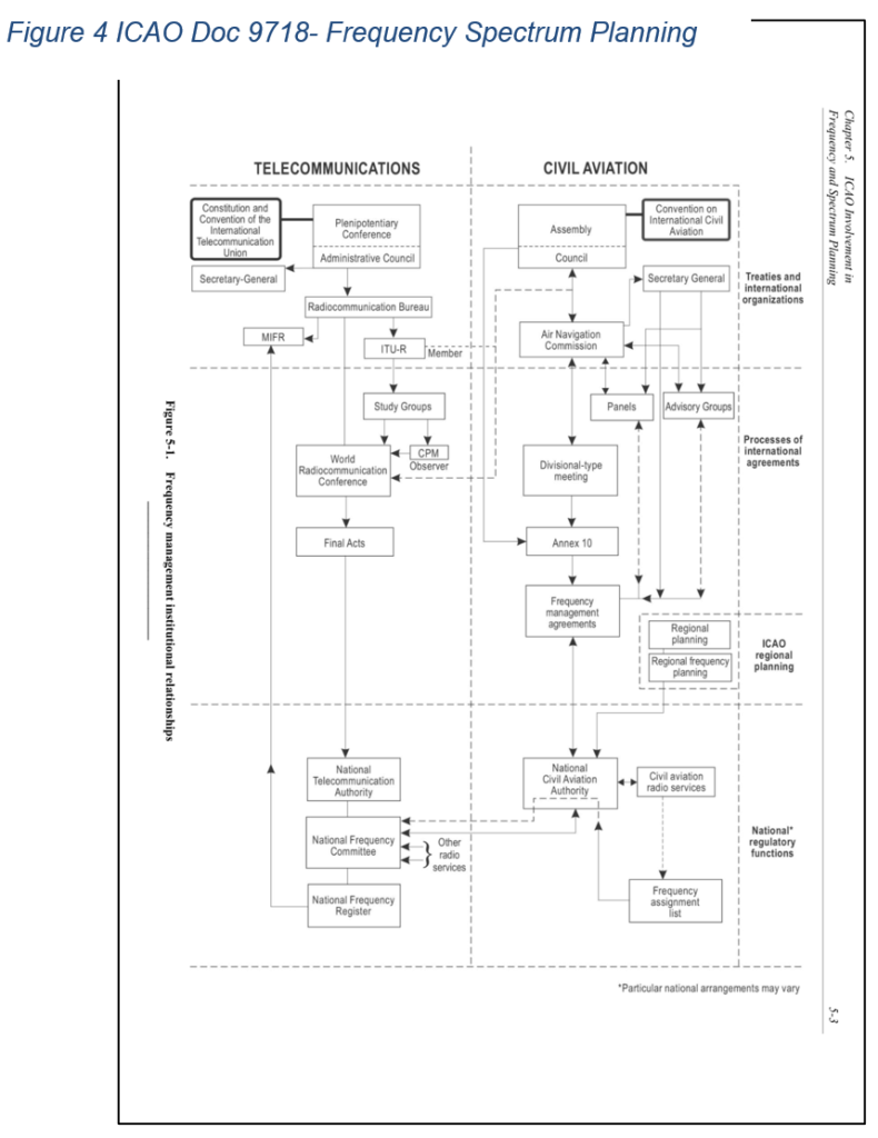
2.5.6. ICAO has an essential role in aviation frequency and spectrum planning.
2.5.7 ICAO Doc 9718 explains that, “Frequency assignment plans for aeronautical communications and navigation systems (with the exception of the HF bands) are usually developed and agreed regionally within ICAO, through the ICAO Regional Offices, using the planning criteria contained in the attachments to ICAO Regional Air Navigation Plans.” Possible frequency allocations for space-based communications would have to be carefully assessed and coordinated to prevent any interference with existing frequencies.
2.5.8 The current IFATCA policy on Aviation Radio Frequency Spectrum Protection (ATS 3.11) is,
| The radio-frequency spectrum shall be managed in a manner that at all times ensures the safety of current aviation activity and allows for future safety-of-flight applications.Existing spectrum allocations for exclusive aviation use shall not allow other uses until it is thoroughly proven that aviation safety will not be compromised by the shared use of the spectrum allocation.Prior to aviation use of shared spectrum allocations, it shall be thoroughly proven that safety-critical aviation requirements are not compromised.
Adequate protection against harmful interference to aviation spectrum use shall be ensured. IFATCA encourages the development of technology which utilizes the frequency spectrum more efficiently |
The policy supports future safety-of-flight applications.
2.5.9. Simply put, VHF radio waves require line of sight. However, the atmosphere bends the radio waves back towards the Earth, thus slightly increasing the range. The higher the aircraft flies, the longer the range is.
2.5.10. Installing transmitter-receivers all over the Globe is not feasible due to high costs, possible maintenance difficulties and the fact that 70% of the surface is covered by water.
2.5.11. Using satellites would increase coverage because of longer line of sight and the possibility to cover remote areas. While it sounds very positive, there is also a negative aspect: it would increase the distance between areas that could use the same frequency.
2.5.12 Startical has set a target for 130 ms delay in transmissions, which basically means real-time communications. Currently, over the North Atlantic, RCP 240 is applied. It is a Performance Based Communication specification, that requires the maximum transaction time to be 240 seconds, 99.9% continuity, 99.99% availability and 10^5 integrity.
2.6 Separation Standards, Airspace Structure and Contingency Procedures
2.6.1. It can be assumed that implementing a Space-Based system for communications and surveillance over Oceanic and/or remote areas would lead to reducing separation standards in those regions. Traffic would be under continuous ADS-B surveillance and two-way VHF coverage. It would mean more capacity and more direct, hence more economical routings. More traffic could fly at their optimal altitude following a preplanned, direct route, reducing fuel consumption. These together would allow airlines to plan less fuel, which in consequence would make aircraft lighter.
2.6.2. Reducing separation minima would have to be investigated by ANSP’s and CAA’s.
2.6.3. Space-Based features, like any other implementation in aviation, should be thoroughly tested before utilizing them to their full capacity. Therefore, proper contingency procedures should be in place before implementation, and safety of air traffic guaranteed even if the whole system collapses leaving air traffic controllers without any surveillance data and/or two-way communications.
2.6.4. Capacity of surrounding airspace should be taken into account while planning an increase in capacity in Oceanic/remote areas. While Space-Based technology would dramatically increase possibilities in less-utilized airspace, neighboring sectors can already be at the top of their capacity and unable to take more traffic from now-quieter areas. Also, if the neighboring airspace does not utilize similar technologies, traffic flow towards that direction can not necessarily be increased.
2.6.5. IFATCA already has a policy on determining operations readiness of new ATM systems (AAS 1.13). It calls for an active inclusion of operational controllers in the design, development and implementation of new ATM systems.
2.7 Training
2.7.1 IFATCA policy on Automatic Dependent Surveillance (ADS) Control Rating (TRNG 9.4.5) states that:
Control of aircraft via ADS and Controllers/Pilot Data Link Communication (CPDLC) is sufficiently different to other forms of ATC rating to warrant comprehensive training and a separate rating.The training syllabus should inter alia contain instruction in:
|
2.7.2 It means that, depending on the current ratings of the controllers, a lot of additional training could be required. Many service providers are understaffed, and assigning operational controllers to training could lead to temporarily reduced capacity numbers.
3. Conclusions
3.1. Space-Based technology would improve global ATM by expanding surveillance and two-way radio communications coverage.
3.2. Contingency procedures should be in place, taking into account possible signal interferences – both natural and artificial.
3.3. ANSP’s would get the data from commercial companies which could create problems in case of system malfunctions or financial difficulties.
3.4. To ensure proper utilization of these systems both ANSPs and CAAs would need to be engaged in their development. Additionally, it is critical that active operational controllers be engaged at all stages.
4. Recommendations
4.1 It is recommended to accept this working paper as information material.
5. References
Australian Space Weather Forecasting Centre. (n.d.). The Diverse Effects of Solar Events
[HTML]. Retrieved from https://www.sws.bom.gov.au/Educational/1/3/6Eddy, J.A. (2009). The Sun, the Earth, and Near-Earth Space [PDF]. Retrieved from https://lwstrt.gsfc.nasa.gov/images/pdf/john_eddy/SES_Book_Interactive.pdf
ESA. (2020). Low Earth Orbit [HTML]. Retrieved from https://www.esa.int/ESA_Multimedia/Images/2020/03/Low_Earth_orbit
IAU. (2020). Satellite Constellations [HTML]. Retrieved from https://www.iau.org/public/themes/satellite-constellations/
National Research Council. (1995) Orbital Debris, a Technical Assessment [PDF]. Retrieved from https://doi.org/10.17226/4765
Wikipedia. (n.d.). North Atlantic Tracks [HTML]. Retrieved from https://en.wikipedia.org/wiki/North_Atlantic_Tracks
ICAO. (2022). Doc 9718 Handbook on Radio Frequency Spectrum Requirements for Civil Aviation (2nd Ed.). Retrieved from https://www.icao.int/safety/FSMP/Documents/Doc9718/Doc.9718%20Vol.%20II%202nd%20Edition%202022_corr000.pdf
ICAO. (2023). North Atlantic Operations and Airspace Manual V.2023-1 [PDF]. Retrieved from https://www.icao.int/EURNAT/EUR%20and%20NAT%20Documents/NAT%20Documents/NAT%20Documents/NAT%20Doc%20007/NAT%20Doc%20007%20Ed%20V.2023-1_eff%20Jan2023.pdf
ICAO. (2022). Resolution A41-21 [PDF]. Retrieved from https://www.icao.int/environmental-protection/Documents/Assembly/Resolution_A41-21_Climate_change.pdf
ICAO. (2023). Space based VHF Datalink: Concept of Operations [DOC]. Retrieved from https://www.icao.int/safety/FSMP/MeetingDocs/FSMP%20WG16/WP/FSMP-WG16-WP18_Attachment_Space%20Based%20VHF%20datalink%20concept_v1.1.docx
IFALPA & IFATCA. (2023). Disruption of Satellite Based Signals, Position Paper 23POS25 [PDF]. Retrieved from https://www.ifatca.org/wp-content/uploads/ifatca-ifalpa-23pos25-disruption-of-satellite-based-signals.pdf
IFATCA. (2015). AAS 1.13 Determining Operations Readiness of New ATM Systems [HTML]. Retrieved from https://ifatca.wiki/kb/aas-1-13-determining-operations-readiness-of-new-atm-systems/
IFATCA. (2019). ATS 3.11 Aviatio Radio Frequency Spectrum Protection [HTML]. Retrieved from https://ifatca.wiki/kb/ats-3-11-aviation-radio-frequency-spectrum-protection/
IFATCA. (2019). TRNG 9.4.5. Automatic Dependant Surveillance (ADS) Control Rating [HTML]. Retrieved from https://ifatca.wiki/kb/trng-9-4-5-automatic-dependant-surveillance-ads-control-rating/
IFATCA. (2017). Virtual Centres – Review ATS 3.15 Functional Blocks of Airspace [HTML]. Retrieved from https://ifatca.wiki/kb/wp-2017-84/
IFATCA. (2016). Space Weather. WP No. 166, 55th annual conference, Las Vegas, USA [HTML]. Retrieved from https://ifatca.wiki/kb/wp-2016-166/
Kulu, E. (n.d.). What is a Nanosatellite? [HTML]. Retrieved from https://www.nanosats.eu/cubesat
Startical www.startical.com
ENAIRE www.enaire.es
Indra www.indracompany.com
https://www.navcanada.ca/en/news/blog/one-step-closer-to-global-air-traffic-surveillance.aspx
www.skykraft.co.au
www.aireon.com

