
DISCLAIMER
The draft recommendations contained herein were preliminary drafts submitted for discussion purposes only and do not constitute final determinations. They have been subject to modification, substitution, or rejection and may not reflect the adopted positions of IFATCA. For the most current version of all official policies, including the identification of any documents that have been superseded or amended, please refer to the IFATCA Technical and Professional Manual (TPM).
64TH ANNUAL CONFERENCE, Abu Dhabi, 28 April – 2 May 2025WP No. 98GNSS RFI and Effects on ATMPresented by TOC |
| SUMMARY Procedures and systems in modern aviation rely more and more on Global Navigation Satellite System (GNSS) data. However, intentional GNSS Radio Frequency Interference, referred to as GNSS RFI is a growing issue. The aim of the paper is to inform the reader about the risks that GNSS RFI is causing to the aviation system. It is done by raising awareness of the general topic, explaining the background, the risks and dangers. The paper also looks into possible methods of mitigation. The already existing policy is being reviewed and the need for additional procedures is taken into consideration. |
Introduction
1.1. According to the European Union Aviation Safety Agency (EASA), there has been a significant increase in GNSS RFI since February 2022 (EASA, 2025). GNSS RFI occurs particularly in regions surrounding conflict zones and other sensitive areas. As of recently, there has been a rise in both GNSS jamming and spoofing. There is a need to promote awareness, knowledge, and investigate possible mitigation procedures and tools.
1.2. Intentional GNSS RFI can be divided into two categories: jamming and spoofing.
1.2.1. Jamming
1.2.1.1. In jamming, receivers are blocked from locking onto satellite signals and the working of the system in the jammed area is greatly reduced to the point of uselessness.
1.2.1.2. Receiving position and time outputs in case of jamming is not possible. Jamming effects are generally detected by avionic systems and often alerts are provided to the flight crew. (Skybrary, 2025)
1.2.1.3. Although jamming can usually be detected, thanks to different avionic systems, detection cannot be guaranteed, and a certain level of uncertainty has to be accepted and anticipated.
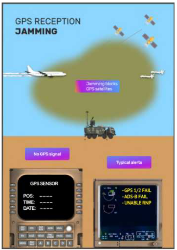
What is Jamming? How does it work and what display can be expected in the flight deck. (OPS Group, 2024a)
1.2.2. Spoofing
1.2.2.1. A second, independent phenomenon which is often discussed alongside jamming is spoofing. Spoofing is a serious form of GNSS RFI, because the effects are potentially more dangerous to safety.
1.2.2.2. Spoofing involves broadcasting counterfeit satellite signals to deceive GNSS receivers, causing them to compute incorrect position, navigation, and timing data. Spoofing events are not automatically detected and consequently no alert is provided to the flight crew (14th Air Navigation Conference, 2024, WP63). These issues particularly affect the geographical areas surrounding conflict zones, e.g. the Black Sea and the Middle East.
1.2.2.3. From a report compiled by OPS Group in 2024, we know that spoofing is a very effective mechanism to counter drones, which are increasingly used in modern warfare. Spoofing platforms and devices are operated in general by military units. OPS group is a non-governmental organization made up of aviation professionals like pilots, ATCOs and dispatchers putting together easy to understand information (OPS Groups 2024).
1.2.2.4. It is not currently possible to detect affected areas from a distance, making pilot reports the main source of information. There are also projects which collect all reports and publish these on different websites for a practical overview of recent incidents.
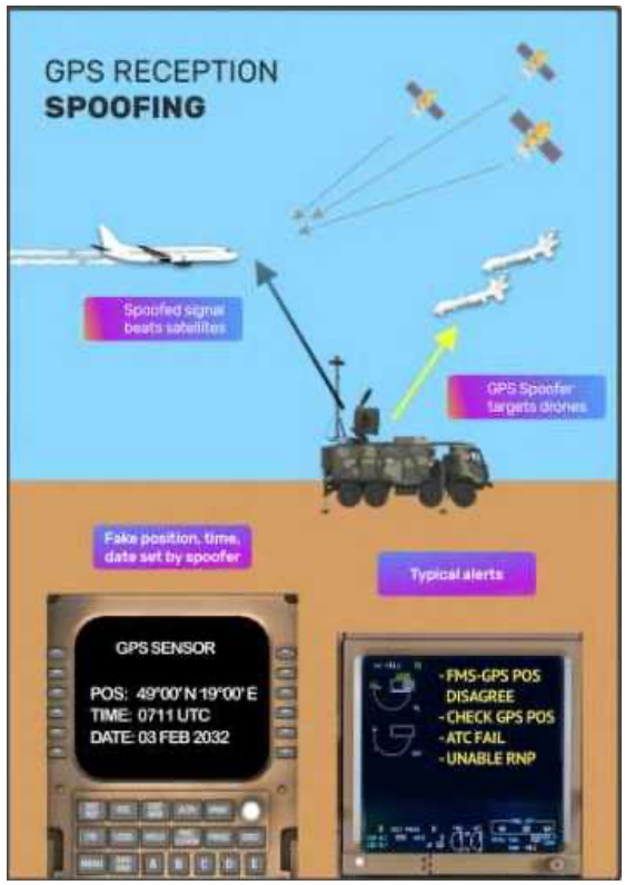
What is Spoofing? How does it work? What data can you expect in the flight deck? (OPS Group, 2024a)
1.2.2.5. In the flight deck, indications of possible GNSS RFI include onboard system indications, such as: GNSS degradation messages, gross discrepancies between the aircraft’s shown and expected position, suspicious time indications, etc. (Skybrary 2025)
1.2.2.6. There are several ways a controller may be notified about GNSS problems, in their own sector or for aircraft under their control. The crew may communicate this to ATC, depending on the phase of flight and what effects are prevailing in the flight deck. It should be noted at this time, there is no standardised phraseology in place to convey the issue.
1.2.2.7. Aside from GNSS RFI reported by flight crews, the controller can suspect it, if they witness trajectory deviations, unexpected turns on the situation display or receives a request to confirm the position of the aircraft or the exact time. Delayed or undelivered Controller Pilot Data Link Communications (CPDLC) messages could also indicate GNSS RFI.
Discussion
2.1. GNSS RFI, especially spoofing, can affect multiple aircraft systems directly and indirectly, thus increasing pilots’ and controllers’ workload. In this section we look into possible system issues and their consequences.
2.1.1. Ground Proximity Warning Systems (GPWS) & Enhanced Ground Proximity Warning System (eGPWS)
2.1.1.1. As eGPWS relies only on a valid GNSS position and it could generate false warnings in unexpected places, e.g. terrain warnings even in CRZ-levels. This can happen long after the spoofing event itself. eGPWS works with GPS positioning data whereas its older brother, the legacy GPWS is not affected by GNSS spoofing as it uses the radio altimeter to detect terrain below.
2.1.1.2. If eGPWS creates false alerts, the flight crew will have to deal with the issue; some airlines have updated their Standard Operating Procedures (SOP) regarding eGPWS to address this scenario, according to reports by pilots.
2.1.1.3. Workload on the flight deck side is expected to be high (OPS Group, 2024). Clear and unambiguous phraseology can help to reduce workload by structured voice communication procedures.
2.1.2. Required Navigation Performance (RNP) Routes or Approaches
2.1.2.1. Due to the degraded or wrong position data of the aircraft, certain procedures are not available to the aircraft anymore, as the needed accuracy is not provided by the avionics system.
2.1.2.2. Aircraft may not be able to fly the flight plan route based on GPS waypoints or procedures like RNP approaches.
2.1.2.3. If the pilot is unable to fly a particular approach, they might will a different approach type (based on ground based navigational aids), a different runway or even a diversion to another airport.
2.1.3. Entry to transatlantic routes may require increased separation and/or will only be allowed outside of RVSM airspace.
2.1.3.1. RNP4 is the current requirement to cross the NAT HLA (North Atlantic High Level Airspace) on most tracks. Aircraft affected by GNSS RFI are often degraded to RNP10 or even lower, which disqualifies them for these tracks. ATC then has to check if other flight levels and routes are available with the degraded navigational and communication capabilities (e.g. CPDLC unavailable) of the aircraft. Increased separation requirements and other procedures may have to be applied.
2.1.3.2. Due to fuel planning, this could ultimately lead to diversion requests and therefore to an increased workload on both the crews and ATCOs.
2.1.3.3. An early report by the flight crew gives ATC more time to coordinate alternative levels or routings, in order to avoid a diversion. (OPS Group Spoofing Final Report)
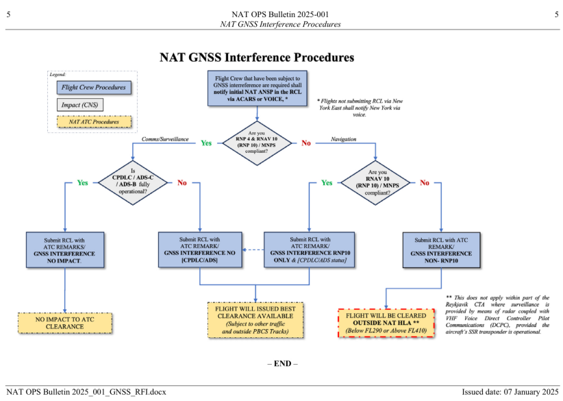
- In the figure above (ICAO, 2025) there are Examples of which systems are needed to fly in certain airspaces to see the operational effect of its failure.
- For example (as elaborated above) the North Atlantic Crossing might be only available below FL290 and above FL410, both options are rarely possible for aircraft due to weight and fuel restrictions, thus leading to increased ATCO workload again due to diversion requests.
2.1.3.4. Pilots might ask about the current time, and they might detect certain jumps in the aircraft’s time system or not having a time at all.
2.1.4. Negative effects on CPDLC (Controller Pilot Data Link Communications)
2.1.4.1. As the timing data is used to operate the CPDLC system, the use of CPDLC might be disrupted. CPDLC messages from the ATCO may not be sent out by the system or may not be received by the aircraft. The message delivery might be extremely delayed. CPDLC log-on of the aircraft will not be possible due to the timing discrepancy.
2.1.4.2. In many airspaces (predominantly non-radar environments, such as oceanic crossings), CPDLC is a requirement. CPDLC failure excludes affected aircraft from entering these sectors. One example is the north Atlantic airspace, where the NAT Data Link Mandate (DLM) mandates CPDLC for flights between FL290 and FL410. (ICAO 2025, NAT OPS)
2.1.5. Automatic Dependent Surveillance – Broadcast (ADS-B)
2.1.5.1. GPS is the primary source of position information for the broadcast of aircraft position through ADS-B. Regulations and standards for ADS-B generally assume the availability and use of GPS signals for position broadcasting (OPS Group, 2024)
2.1.6. All other systems or procedures that require accurate position or time data from the satellite network. These include, but are not limited to Radio Navaid Tuning, HeadUp Display, Runway Awareness & Advisory System, Emergency Locator Transmitter. (OPS Group 2024 & IFATCA & IFALPA, 2025)
2.2. In general, the extent of consequences on the pilot might differ significantly depending on the aircraft manufacturer and/or the manufacturer of the avionics and flight computers.
2.2.1. Some aircraft detect deteriorating GNSS status and notify the crew who can manually disconnect the satellite-based navigation and continue by navigating using only ground-based navaids and inertial navigation. In this case navigation will not be an immediate problem enroute.
2.2.2. For other aircraft types and other avionics manufacturers this is not possible as they are not equipped with the needed technology. They rely on the vigilance of the cockpit crew to detect certain trigger data like missing time data or jumping position data and they will need assistance by ATC for example by requesting headings.
2.3. Impacts on ATCOs will vary depending on the type of airspace – as there might be different navigational requirements prevailing- or on the navigational accuracy of the aircraft involved. Another impact factor might be the task to apply higher separation to some aircraft as required and described above. All this leading to a much higher workload to handle the traffic.
2.3.1. In an enroute ACC environment, providing radar vectors to the pilots might be the only solution, if the aircraft is not able to continue on its own navigation or seems to be off track without recognizing it already.
2.3.2. If numerous aircraft are affected in the area and require radar vectors, the workload of the ATCOs will increase significantly. This has the potential to cause a cascade of problems that might lead to Flight Information Region (FIR) wide problems, including issues with ATC staffing due to increased workload.
2.4. Almost all current GNSS spoofing incidents affecting civil aircraft are related to conflict zones. However, resetting systems after clearing the area of interference is not always possible. As a consequence, degraded system capabilities can affect the rest of the remaining flight. (OPS Group, 2024, Crew Guidance Manual)
2.5. Recent prominent examples of GNSS RFI and its effect on aviation
2.5.1. Up to May 2024, the airport of Tartu only had approach procedures based on GPS. As several flights of Finnair into Tartu were affected by GNSS RFI, the airline decided to suspend flights into the Estonian airport for safety reasons. They published this pause of service for about a month to establish alternative for the approach into Tartu. After ground-based navigational aids had been put in service, the airline resumed operations into Tartu. (Aviation Direct, 2024 & Tartu Airport, 2024)
2.5.2. On December 5, 2024, an Azerbaijan Airlines E190 was shot down over Russia, near Grozny which was the original destination of this flight originating in Baku, Azerbaijan. Prior to the incident, it was on the approach into Grozny and reporting that both GPS had no signal, and they would need the NDB approach. After an unstable approach that resulted in a Go-Around, the ATCO again wanted to clear them for a GNSS-based procedure for the second approach. The crew once more had to explain that they were unable to fly this procedure. This misunderstanding was not helped by the non-existence of harmonised phraseology, for GNSS RFI situations. (Kazakhstan Government, 2025)
2.6. Phraseology
2.6.1. The previously mentioned Azerbaijan Airlines flight is an example of the need for a common and harmonized phraseology, for GNSS failure situations.
2.6.2. Due to the increase of GNSS RFI and the growing effect on the ATM system, there is a need for a harmonized phraseology. This will help mitigate the increase in workload, due to specific procedures and phraseology, which allows a precise understanding between ATCOs and flight crews.
2.6.3. As there is no global and therefore no harmonised phraseology, IFATCA should advocate for the development of unambiguous and easily understood new phraseology. Examples could be but not limited to:
- aircraft: Experiencing GNSS interference.
- aircraft: Unable RNP / approach due to GNSS interference.
- aircraft: Negative CPDLC due to GNSS interference.
- aircraft: Request Heading due to GNSS interference.
- aircraft: (E)GPWS climb due to (possible) GNSS interference.
2.7. Current mitigation measures
2.7.1. Mitigation of GNSS RFI is quite complicated and there are no simple solutions. In general, mitigation procedures can be divided in two categories:
- technical solutions
- awareness campaigns and training
2.7.2. Mitigation by technical solutions
2.7.2.1. There are several technical ideas to prevent GNSS RFI.
2.7.2.2. Using other frequency bands is not a solution, even if they are presently less frequently spoofed.
2.7.2.3. The technical solution of using Controlled Reception Pattern Antennas (CPRA) might be an interesting approach, in the mid- or long-term. However, these are not yet certified for civil aviation and are very expensive.
2.7.2.4. Better detection methods of GNSS RFI are another way to go. Some companies offer these products already outside of the aviation market, but not for aviation as they are not certified for the use in avionics systems.
2.7.3. Mitigation by awareness
2.7.3.1. Another means of mitigation is creating awareness about this topic and training of crews and ATCOs.
2.7.3.2. If pilots are aware that a flight will transit through an affected region, reviewing procedures, technical capabilities of the aircraft and recovery procedures provided by the operator or the manufacturer can aid safe operations in these areas.
2.7.3.3. Briefings about topics like “Which areas are affected?”, “What systems can be affected?” or “How to detect Jamming & Spoofing” aid preparation before traversing the above-mentioned areas.
2.7.3.4. The same is valid for ATCOs: Being aware and being trained for possible affected airspaces in the area and how to deal with aircraft reporting or even not reporting (but experiencing) GNSS RFI is a very effective way to ensure safe operations.
2.8. IFATCA’s actions and statements
2.8.1. IFALPA and IFATCA urge States to retain conventional navigation equipment as a contingency, in case civil aircraft are negatively affected by GNSS RFI.
2.8.2. In the WP78 presented at the 14th Air Navigation Conference by several organizations (including IFATCA), it is clearly mentioned that States are recommended to establish a minimum network of conventional, ground based navigational aids and retain them beyond 2030 or at least until new failsafe procedures for GNSS are established. (ICAO, 2024, WP78)
2.8.3. A minimum operational network of conventional ground-based navigation aids is paramount to guaranteeing robust and resilient air navigation.
2.8.4. IFALPA and IFATCA are supporting the development of mitigation strategies to counter the hazardous effects of GNSS RFI on civil aviation. (IFALPA & IFATCA, 2024)
2.8.5. IFATCA is coordinating closely with the International Federation of Air Line Pilots’ Associations (IFALPA) and believe the following aspects should be addressed as a matter of urgency:
2.8.5.1. States should establish the necessary legal framework and act upon harmful GNSS RFI caused by illegal transmitters, jamming/spoofing devices, and other sources of electromagnetic radiation, and avoid their commercialisation, proliferation, and use.
2.8.5.2. States should assess the interference risks associated with conflict zones and consider that satellite-based CNS systems can potentially be impacted well beyond those zones.
2.8.5.3. A civil military coordination should facilitate the sharing of relevant information with airspace users either during civil or military testing and/or other activities, or when flying in the vicinity of a conflict zone.
2.8.5.4. As a resilience measure, fuel planning should take signal outage into consideration. Approach procedures to destination and alternate should not depend solely on GNSS. (IFALPA & IFATCA 2025)
2.8.6. IFATCA wants a system that can be functional regardless of the type of interference, therefore GBNA (Ground Based Navigational Aids) are paramount for the safe operation without possible GNSS RFI and the above listed risks.
2.9. Other organizations
2.9.1. Authorities and different organizations have become increasingly more aware of GNSS interference. There is a tremendous amount of published information about the issue, including safety alerts and recommendations. To mention a few:
- OPS Group has collected a lot of data and come up with guidance material for pilots, which gives them necessary information and ways to minimize the impact when flying into an area affected by GNSS RFI. (OPS Group 2024, Crew Guidance)
- The International Air Transport Association (IATA) published a list of recommendations in 2019 including:
- States and ANSPs should analyse the risk level of harmful interference of GNSS and establish contingency procedures and infrastructure as appropriate. (IATA, 2019)
- The Federal Aviation Administration’s (FAA) Safety Alert for Operators 24002, dated 25 January 2024, gives multiple recommendations, including this example:
- Ensure NAVAIDs critical to operation for the intended route/approach are available.
- The European Union Aviation Safety Agency (EASA) has published revisions for the Safety Information Bulletin (SIB) 2022-02. The SIB is targeted at many different stakeholders, providing information, guidance and recommendations.
- They have multiple recommendations for ATM/ANS providers including:
- Consider keeping a ground navigation infrastructure operational such as ILS, DME, and/or VOR in support of conventional and performance-based navigation procedures.
- Make sure that the surveillance coverage is resilient to GNSS interference.
- For areas, where surveillance remains exclusively based on ADSB, ensure that appropriate contingency procedures are available, when GNSS jamming or spoofing is detected.
- In areas affected by GNSS jamming and/or spoofing promote the use of conventional navigation flight procedures or performancebased flight procedures using VOR/DME.
- Be prepared to provide navigation assistance to aircraft (using radar vectoring) as long as needed. (EASA, 2022)
2.10. ICAO
2.10.1. In one of many Working Papers present at the 41st ICAO General Assembly, Working Paper 97 provides several conclusions:
2.10.1.1. The ICAO Assembly encourages States to transition towards optimised satellite and ground-based infrastructure which is resilient and robust against any type of interference and keep the terrestrial CNS available in the long term to ensure safe operations.
2.10.1.2. ICAO encourages the authorities and industry to develop interference detection, mitigation and reporting capabilities to prevent negative effects of compromised position, velocity or time data. (ICAO, 2022)
2.11. IFATCA in hindsight and today
2.11.1. As early as 1999, IFATCA started to publish a policy regarding the dismantling of ground-based navigational aids. It states that the wholesale removal of terrestrial navigation aids is neither feasible nor safe. (IFATCA, 1999)
2.11.2. Although the policy was not originally intended towards intentional GNSS RFI, it still applies to the subject matter, without a need for revision.
2.11.3. The IFATCA policy on Removal of Ground Based Aids was updated most recently in 2022 and still reflects the Federation’s position today.
2.11.4. GNSS is not only vulnerable to intentional interference, although it has obviously become a hot topic due to its increase during the recent years. However, it should not be forgotten that also natural phenomena like space weather and unintentional disturbances, caused for example by television broadcast antennas, can interfere with GNSS signals. IFATCA has published a working paper on space weather’s negative effects on aviation. It describes the phenomenon and its consequences for space-based navigation. (IFATCA, 2016)
2.11.5. The existing policy is available on the IFATCA TPM where the AAS 1.9 policy is deemed still strong and valid. (IFATCA, 2024)
IFATCA Policy is:AAS 1.9 REMOVAL OF GROUND BASED AIDS Unless failsafe procedures are in place, the removal of terrestrial navigation aids is neither feasible nor safe. The persisting vulnerabilities in navigational systems require the maintenance of a terrestrial navigation infrastructure. |
Conclusion
3.1. A lot of information about the increasing phenomenon of GNSS RFI exists and much more has been published recently. Working groups like the OPS Group, ANSPs, manufacturers, and international organisations like IFALPA and IFATCA have published awareness papers, guidance material. It can be expected that more is to come, if the trend of increased GNSS RFI persists. The increased occurrence of this phenomenon has also captured the attention of ICAO and the associated issues are high on its agenda.
3.2. While existing IFATCA policy is still valid, it is recognised that certain issues require additional attention:
- There is a need for global and harmonised phraseology to report GNSS RFI;
- There is a need for global and harmonised phraseology reporting eGWPS alerts.
Recommendations
4.1. It is recommended that IFATCA advocates for the creation of unambiguous and easy to use phraseology for reporting GNSS interference and its associated issues pertaining to the safe execution of flights.
4.2. It is recommended that this paper is accepted as information material.
References
Airport.EE. Finnair Resumes Flights to Tartu, 10 June 2024, http://www.airport.ee/en/finnair-resumes-flights-to-tartu/
Aviation Direct. “GPS Disruptions: Finnair Has to Suspend the First Route.”
Aviation.Direct, 29 Apr. 2024, http://www.aviation.direct/en/GPS-problems-Finnair-has-tosuspend-the-first-route
EASA. “EASA (2022), Safety Information Bulletin 2022, No. 2.” EASA, 17 Mar. 2022, http://www.easa.europa.eu/en/sib-2022-02
EASA. (2025) “Global Navigation Satellite System (GNSS) Outages and Alterations.” EASA, 2025, http://www.easa.europa.eu/en/domains/air-operations/global-navigation-satellite-system-outages-and-alterations
IATA. Harmful Interference to Global Navigation Satellite System …, 29 Apr. 2019, http://www.iata.org/contentassets/d7e421981aa64169af1a8d6b37438d4d/tib-gnss-interference-final.pdf
ICAO. Improving Communication Navigation and Surveillance (CNS …, 28 July 2022, http://www.icao.int/Meetings/a41/Documents/WP/wp_097_en.pdf
ICAO. AVIATION SAFETY AND SECURITY CONCERNS REGARDING INTERFERENCE TO THE GLOBAL NAVIGATION SATELLITE SYSTEM (GNSS), 14th Air Navigation Conference, 2024, http://www.icao.int/Meetings/anconf14/Documents/WP/wp_063_en.pdf
ICAO, 2024, 14th Air Navigation Conference, WP78, RATIONALIZATION OF NAVIGATION INFRASTRUCTURE, retrieved from https://www.icao.int/Meetings/anconf14/Documents/WP/wp_078_en.pdf
SYSTEM (GNSS) INTERFERENCE MITIGATION, retrieved from https://www.icao.int/Meetings/a41/Documents/WP/wp_097_en.pdf
ICAO Nat OPS Bulletin (Jan 07th, 2025), NAT GNSS Interference Procedures, Retrieved from https://www.icao.int/EURNAT/Pages/EUR-and-NAT-Document.aspx
ICAO. “EUR and NAT Documents.” EUR and NAT Documents, 2025, http://www.icao.int/EURNAT/Pages/EUR-and-NAT-Document.aspx
IFATCA & IFALPA (2024) Joint PR IFACTA-IFALPA, retrieved from: https://ifatca.org/ifatca-ifalpa-joint-press-release-on-gnss-interferences/
IFALPA & IFATCA (2025) Disruption of Satelite-Based-Signals, retrieved from: https://www.ifalpa.org/media/4040/23pos25-disruption-of-satellite-based-signals.pdf
IFATCA. “Removal of Ground Based Aids.” Removal of Ground Based Aids, 2024, http://www.ifatca.wiki/kb/wp-1999-98/
IFATCA. “Space Weather.” Space Weather, 2016, http://www.ifatca.wiki/kb/wp-2016-166
Kazakhstan Government, 2025, Preliminary Incident Report on Flight J2-8243 retrieved from: https://www.gov.kz/uploads/2025/2/4/84f9ee83af415a658fc3d2830d317889_original.3875924.pdf
OPS Group. (2024a) “Crew Guidance GPS Spoofing.” OPS.Group, http://www.ops.group/dashboard/wp-content/uploads/2024/09/GPS-Spoofing-Crew-GuidanceWG2024-OG1.pdf
Ops Group. (2024b) “GPS Spoofing Final Report.” OPS.Group, 2024, http://www.ops.group/dashboard/wp-content/uploads/2024/09/GPS-Spoofing-Final-ReportOPSGROUP-WG-OG24.pdf
Skybrary. “GNSS Jamming and Spoofing.” GNSS Jamming and Spoofing | SKYbrary Aviation Safety, 2025, http://www.skybrary.aero/articles/gnss-jamming-and-spoofing

